Since my Conquest Sport junior cyclocross bike came with disc mounts and hubs, not to mention the world's worst cantilever brakes, I've always thought of upgrading to disc brakes. What would make it even better would be to put a 2X10 drivetrain on it like my real cyclocross bike has. I'm pretty much over triple cranks, don't use the small one hardly ever, and with the Sram Apex you can get the bike set up with about the same range of gears with a double as a triple (or so they say). For riding to work and back and around town, I might just prefer a single up front but there's those occasions like hauling up to 5-Mile or the South Hill or charity rides when I might need a wider gear range than a single would provide.
I've thought about going the custom route, but I don't feel I know enough about what I want or need in a bike frame so I've put that thought on hold. I'm a little partial to Redline and they're coming out with the Conquest Disc with Shimano Tiagra 2 x 10 which caught my eye. (update: just saw the new Metro Classic with discs and triple crank). Then I was innocently looking at bikes on either Universal Cycles' or Salsa's website when I stumbled across the Salsa Vaya. Might've seen it before, but this time it jumped out at me. Disc brakes, Sram Apex 2X10, nice bright orange paint - just what I want. Plenty of room for tires & fenders. Perfect for town, city, gravel, road, dirt. Steel, so it might be a little heavy hauling up and down our stairs (I really need to get the second remote for our garage door opener working). Too bad Bicycling magazine featured it in their Sept issue, now everybody will want one.
I did some calculating. Ok it'd be cheaper to upgrade the Sport but the impulse part of my brain says it'd be easier to just get the Vaya. I think I could do some wheeling and dealing and come up with the do-re-mi. If I could find one to try. I did find one online in what might be my size on the other side of the continent, but should probably wait for the new models to come out. Salsa's website lists Steve's on Cannon as a dealer, I'll have to check with them. I also read online from an old post that non-dealer bike shops can order them, but it's iffy what's available after the dealers place their orders.
But then I picked up my blue Redline from the shop after it was in for a tuneup, and boy it rides smooth. Really seems to fit me. A couple people have complimented the bike lately, too so I feel bad thinking of abandoning it or hanging it in the garage to ride occasionally. My new bike fever has gone down a bit, but I'm still anticipating/waiting to see what the 2013 Salsa lineup will bring.
Shoot what's that? Surly is coming out with the Krampus, a 29er+ with 3" tires. Totally different direction, but wonder how that'd work...
Tuesday, August 28, 2012
Saturday, August 25, 2012
Kendall Yards - Centennial Trail
One of the neat (did I just say neat?) things happening in Spokane is the plans by the developers of Kendall Yards to complete the section of the Centennial Trail from the Monroe Street Bridge to the Sandifur bridge. I've been wondering if the trail will go under the bridge making it easy to cross Monroe so I rode there after work Monday to check it out. It does look like it will go under the bridge, but I should check with the Kendall Yards folks to find out for sure. I've tried to cross Monroe there and it can take some patience.
They have the trail laid out and somewhat graded from Monroe to the intersection of Ohio and Falls Ave/Elm Street. I'm not sure where they're going to put the trail for the section past Elm, if it'll be alongside Ohio Street or off to the side.
I like to think I'm comfortable riding on the street with traffic, but it'd be great to have a nice traffic free paved trail to take west to Summit Blvd sometimes. I ride down Broadway to Summit on my way home sometimes, and though it takes me a little further west than I need to go before turning up North to the Shadle area, it might be quicker than my usual routes home because I can ride for long stretches uninterrupted by stop signs or intersections.
My iPhone battery drained on the last camping trip and refuses to charge and sync back up (darn, just in time for iPhone 5), so I wasn't able to take any pictures.
Thursday, August 23, 2012
biking & lightning
Tuesday morning we had a good storm. Started out a few rain drops, then more. Thought it was just a teaser storm, but soon rain was falling hard. Wasn't too worried about it, seemed like it would pass pretty quickly... and then the thunder started. Real close. A few lightning flashes nearby. I started wondering, what are the chances of getting struck by lightning biking to work? I haven't had the best of luck this year.
Coincidentally, my usual bike-to-work blue Redline was in the shop for a tune-up, and due to be ready for pick-up Tuesday. Instead of riding another bike in my stable, I decided to get a ride to work and walk to the shop after work to pick it up. Did see quite a few bikes out and about Tuesday, so looks like a few braved the storm in the morning.
Coincidentally, my usual bike-to-work blue Redline was in the shop for a tune-up, and due to be ready for pick-up Tuesday. Instead of riding another bike in my stable, I decided to get a ride to work and walk to the shop after work to pick it up. Did see quite a few bikes out and about Tuesday, so looks like a few braved the storm in the morning.
Sunday, August 19, 2012
Williams Lake and environs
We went camping at Williams Lake south of Cheney last weekend. That Thursday (8/9/12) after work me and my bike got a ride out there. I know, I wimped out and didn't bike there, but we had a kayaking expedition with the Parks & Rec dept at 5pm I had to make.
While my wife had to work Friday morning, and took the dogs with her, I of course got to go on a bike ride. I'm not too familiar with the roads out there, but headed out going west-southish on Mullinix Rd with no particular destination in mind and soon came across this sign:
 but instead of turning right on to Martin Rd, I continued on Mullinix Rd which was now a gravel road. I was on my Redline Conquest Sport with 35mm Pasela tires - not really set up for trail riding, and I wanted to do some exploring. (Wait, now that I think about it, I did ride the Plateau trail on this bike last year, and on 32mm tires to boot. But that was on the section between Fish Lake and Amber Lake. It's a slightly rocky section, but past Martin Rd the trail is full-bore railroad ballast.)
So I rode Mullinix to JW Henderson Rd to Belsby Rd. Not much traffic, which was nice, just a few farm trucks kicking up dust, one car. And one guy on a bike, wandering around the back roads.
What's funny, is I discovered by looking at Google maps and the atlas, if I had kept on Belsby Rd/Miller Rd and stayed on Belsby, I would've come across the John Wayne Trail near the north end of Rock Lake. But I turned around at Belsby and went back up to Mullinix Rd then went left on Reed Rd and followed it back up to Martin Rd. (I finally broke down and mapped it out on MapMy ride here. sheesh, I just checked the link and there's tons of ads and it makes you sign in or register to view full screen...).
At this point I thought I was past the Martin Rd trailhead, but I went left (west) on Martin anyways, went past a ranch and hunting guide place called Miller's something-or-other and came across a dirt/gravel road. There was an old rusted bullet hole ridden mailbox there with the name of Falk on it. I checked - no mail in it. I took this road and then there it was, the Columbia Plateau trail.

I could just barely make out somebody and a dog on the trail to the south, so I waited for a bit. What other fool is out here on a hot August morning? But they were going the other way and they soon disappeared into the haze.
Ahead on the road was this sign that said Summer Road. It's open for only part of the year, but I thought that was the name of the road. So I'm not too quick sometimes. I also thought I'd gone by a Summer Rd so I thought, good, this will take me back. I had a general idea in which direction Williams Lake lay, and this seemed like it was heading that way.

This is the bike I was on:

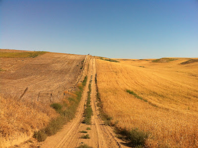
And this is the road I was on now. Is this is what they mean by underbiking?

I walked down one of these hills which was fairly steep as I have the world's worst cantilever brakes on this bike and I still haven't replaced them. After awhile I rode past a farmhouse (Marker #2 on map), some outbuildings and then came to another intersection. The road signs had 3 names on them: Falk, Harris and Scroggie (marker #3). I turned around and read a sign facing the way I came from: Summer Road, 1 1/2 miles. But I thought I was on Summer Road, how'd I get back on Falk? There was a road that veered off by the farmhouse and then looked like it went a bit and then disappeared into the dirt, was that it? Ohhhh....that dirt section was only open during summer, not called Summer and I was always on Falk Rd.
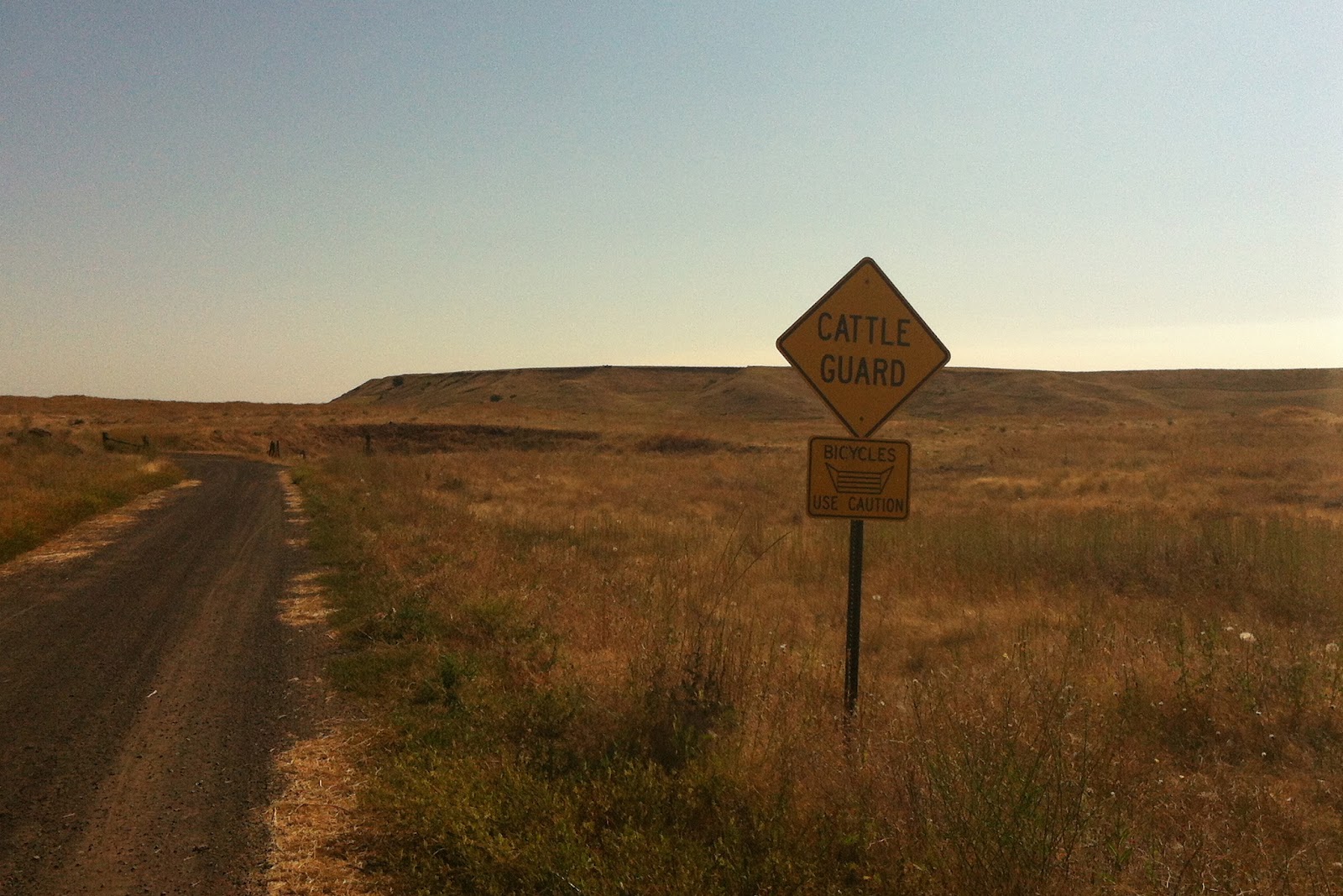
Got a kick out of this sign, apparently there's enough bicyclists out here to warrant a warning sign:
After a false start down Scroggie which seemed like it would head up towards Cheney, I turned down Harris Rd, and after going down it for a ways I started feeling like maybe I didn't really know where I was. I could backtrack and find my way back to the lake, but didn't want to do that. I wasn't too worried yet, I just wanted to be back before Debbie returned from work so she wouldn't wonder where I was. I figured I had at least a couple hours to find my way back before any alarms would be raised, but there's no cell reception at the lake. So I gave in to technology at an intersection with Pine Springs Rd and turned on my phone, which I brought along at the last minute. I've learned it's a good idea to carry a phone in case something goes wrong, like broken bone, stry dog bite, etc. Yea!, there's reception out here. I was still heading in the general direction of Williams Lake, but was veering off to the north of it. I got my bearings and plotted a course back to the campground.
Pine Spring soon intersected the Plateau trail (near Amber Lake):
By taking Pine Springs Rd south, then turning right onto Woods Rd, I arrived back on Mullinix Rd and familiar ground. I rolled into the campground with plenty of time to spare. It was a good ride, about 27 miles in all. These roads deserve some more exploring.
While my wife had to work Friday morning, and took the dogs with her, I of course got to go on a bike ride. I'm not too familiar with the roads out there, but headed out going west-southish on Mullinix Rd with no particular destination in mind and soon came across this sign:

So I rode Mullinix to JW Henderson Rd to Belsby Rd. Not much traffic, which was nice, just a few farm trucks kicking up dust, one car. And one guy on a bike, wandering around the back roads.
What's funny, is I discovered by looking at Google maps and the atlas, if I had kept on Belsby Rd/Miller Rd and stayed on Belsby, I would've come across the John Wayne Trail near the north end of Rock Lake. But I turned around at Belsby and went back up to Mullinix Rd then went left on Reed Rd and followed it back up to Martin Rd. (I finally broke down and mapped it out on MapMy ride here. sheesh, I just checked the link and there's tons of ads and it makes you sign in or register to view full screen...).
At this point I thought I was past the Martin Rd trailhead, but I went left (west) on Martin anyways, went past a ranch and hunting guide place called Miller's something-or-other and came across a dirt/gravel road. There was an old rusted bullet hole ridden mailbox there with the name of Falk on it. I checked - no mail in it. I took this road and then there it was, the Columbia Plateau trail.
 |
| Marker #1 on mapmyride |

I could just barely make out somebody and a dog on the trail to the south, so I waited for a bit. What other fool is out here on a hot August morning? But they were going the other way and they soon disappeared into the haze.
Ahead on the road was this sign that said Summer Road. It's open for only part of the year, but I thought that was the name of the road. So I'm not too quick sometimes. I also thought I'd gone by a Summer Rd so I thought, good, this will take me back. I had a general idea in which direction Williams Lake lay, and this seemed like it was heading that way.

This is the bike I was on:

And this is the road I was on now. Is this is what they mean by underbiking?


I walked down one of these hills which was fairly steep as I have the world's worst cantilever brakes on this bike and I still haven't replaced them. After awhile I rode past a farmhouse (Marker #2 on map), some outbuildings and then came to another intersection. The road signs had 3 names on them: Falk, Harris and Scroggie (marker #3). I turned around and read a sign facing the way I came from: Summer Road, 1 1/2 miles. But I thought I was on Summer Road, how'd I get back on Falk? There was a road that veered off by the farmhouse and then looked like it went a bit and then disappeared into the dirt, was that it? Ohhhh....that dirt section was only open during summer, not called Summer and I was always on Falk Rd.
Got a kick out of this sign, apparently there's enough bicyclists out here to warrant a warning sign:
 |
| on Harris Rd, I think |
 |
| The Columbia Plateau trail, just past Amber Lake (marker #4) |
By taking Pine Springs Rd south, then turning right onto Woods Rd, I arrived back on Mullinix Rd and familiar ground. I rolled into the campground with plenty of time to spare. It was a good ride, about 27 miles in all. These roads deserve some more exploring.
Wednesday, August 15, 2012
the Dreaded Sit-up Bike
Well, it happens. I'm over 50 with mostly gray hair. So every once in awhile I'll walk into a shop and the bike shop guy (not many bike shop gals here) will decide I look like the perfect candidate for an old man bike: the sit-up bike. Even if I've mostly shown interest in the mountain and 'cross bikes. I'm still boycotting one local shop because after I told the guy I ride a combination of street and off-road and was looking for a similar bike for a friend in his 30's, he ignored what I just said and went into his sales pitch that ended up with us over at the sit-up bikes. Then both he and the owner/mgr dissed cyclocross.
I guess it could've been worse: he could've shown me a recumbent.
There are many sit up bike proponents out there. Easier on your back they say. You can see better, having a wider angle of view. All good reasons.
But despite my age, I don't want a sit-up bike. I've seen people try to go uphill on them or try to ride fast. No thanks. I am able to see fine riding to work or around town on my flat bar hybrid Marin or cyclocross bikes. No old man bike for me. Not that there's anything wrong with that.
I guess I shouldn't take it personally. They are a good option for many people, and not just for the over 50 crowd. So maybe I shouldn't slam them as old man bikes.
What's funny is I did get passed once by a guy riding a sit-up bike while I was riding home near Audubon Park during my different week in January. That was sobering. But he was younger, maybe in his early 30's. It did make me rethink them. But I still don't want one.
Yet.
I can see myself someday channelling my grampa, who rode around Ephrata on one of those old 3 speed bikes, sitting up straight and wearing a fedora.
Saturday, August 4, 2012
2.5 days on the JWPT (Part III)
OK let's finish this up...I kinda lost interest in writing this up after a month had gone by, and then my memory started fading, so if any one's still with me here goes. Some details, like where we camped or which roads we took, may be off.
We were rained on just a little bit on Saturday night, but the wind picked up and the tube tent was flapping noisily and waking me up off and on. I finally tore it down around 3 or 4 and slept in the open. Sunday morning arrived bright and early, another beautiful day with a little breeze (cue scary violin music).
Had an early morning visitor checking out our campsite:

Eric offered me a Via packet and hot water to make coffee, which I happily accepted. I had packed some Via packages somewhere in my bag but didn't bring along a little jet stove to heat water with, so I was operating without coffee the past couple days. Roughing it.

Somewhere along the line we ran into a headwind, a slight uphill, and rockier trail conditions and I lost interest in picture taking. Below is the last pic I took on Sunday. I think this is somewhere after the MacCall/Paxton area, after we went under the Columbia Plateau trail trestle.

 |
| The double line going through the "x" in Paxton is where the Plateau trail is, listed on this map as the Fish Lake Trail (the dots leading to Horsehoe Lake Rd) |
On second thought this might be before Revere. Either way, it leaves a lot of trail I didn't document. Luckily, Pat, though slowing down on his own picture taking frequency, did take some pictures of this section for the historical record and they can be found in his report Crossing Washington on the JWPT - Day 2.
I was pretty happy with my mountain bike and trailer setup on this trip, but riding next to Pat in this section I became a bit envious and slightly covetous of his fat tires. My front tire, probably overinflated above 50psi, was bouncing off the rocks all over the place and my handlebars were going every which way with each jolt so I was constantly making steering corrections. Pat's front tire just plowed on straight ahead, paying no attention to those little pebbles in its way.
So we continued on, pedaling away.
And then we came to Marengo.
The wind was picking up. We watched the UP train stop here before its line took it south to Thavis. Our line headed towards Cow Creek, and the section marked "impassable" on the official trail map, due to the trestle over the creek being torn down. The official detour is up to Ritzville but none of us were thinking of going that way. Eric had ridden through the Cow Creek section on a previous trip during the dry season, but we figured it was too marshy and/or deep to get through now in mid-June when the creeks were still high due to spring runoff and the recent heavy rains we'd been getting. The thought crossed my mind, and I'm sure Pat's and Eric's also, to forge ahead and check it out, but I thought it'd be a shame to have to backtrack if we got to Cow Creek only to find we couldn't cross. Drinking water was a concern, but I mentioned I still had a half gallon in the trailer.
So there we were, above the "w" in Cow Creek Road on the map below:

One option was to ride the active rail line down to Thavis. There was also a dirt road staring at us across the intersection with the UP railroad, posted no trespassing, daring us to try it, but it wan't clear where it went. We rode down Cow Creek Road, which looked promising, but it quickly petered out into a couple dirt roads marked with no trespassing signs. One road appeared to lead where we wanted to go - but it looked like it disappeared into the dirt. If we took it, would we come across an upset landowner, or would it stop in the middle of nowhere? Also, there was a small bluff blocking our view of where this road might lead to, if anywhere. We debated, we rode a bit, turned around. I called my dad - 90 years old last March - and left a message wishing him a happy Father's Day. We thought about it some more. Poured over the maps.
Looking at the above pic of map 67 of the DeLorme Washington atlas, which I bought after the trip to figure it out, you can see the little mouse turd markings of the dirt roads I think we were looking at. It appears they would've headed back up to the trail. It also appears one of them is still on the wrong side of the creek. Who knows? Someday I hope to find out, and also ride the Cow Creek section.
In the end, we spent a lot of time here and we just had to make a decision. I was onboard with riding the railroad line, I think we all agreed it looked like our best option. Rails to trails to rails. It was only a short 3 mile ride to the road.
Right! I quickly discovered riding the railroad wasn't easy, especially with the trailer dragging behind me. Tried riding down the middle, on the edges, to the side when we could. Soon we were all walking our bikes, riding every once in awhile, but mostly walking. And walking. And looking back every once in awhile - the train had already gone past before we started down the line, but ya never know when the next one is coming. Longest 3 miles, I thought maybe we miscalculated and it was actually 10 miles to the road.
We finally reached the Ralston-Benge Road Rd and headed west. The wind really started up, gusting above 20 mph, and we were riding into it. Mostly uphill of course. There was a tree off in the distance at the top of the hill and it became our focus. I just kept my head down, tried not to look up too often at the tree that wasn't getting much closer, and keep pedaling. Eric was amazing, pedaling up ahead of Pat and I.
Eventually, I mean real eventually, we reached the intersection with Klein Rd where the tree was and stopped to rest. Filled up our bottles from the last half gallon in the trailer. Took a well earned rest. I really wanted a hamburger or pizza. And a tall cold beer.
Klein Rd was a real slog. Gravel, rough in spots. We weren't heading straight into the wind anymore, but the sidewind was just as bad, much to our dismay. At one point I was thinking to myself, when or if I get back home, I am only going to ride on the street to and from work, no more off-roading for me. I am sick of riding, just keep pedaling. I looked over at Pat, and he was thinking the same - he said something to the effect of To hell with this bike business! I agreed.
We finally made it to Ralston maybe around 4 or 5? and stopped at the small Memorial park there. We were sort of in limbo, and way off schedule. The mood was somewhat sober, yet I was also happy we were back near the trail. It was only a hundred yards away. We hung out, ate, napped. I wished I'd remembered to bring a book, or playing cards would've been nice. I half wished I'd chanced bringing a mandolin to play, but I wasn't sure how I would've packed one without it getting broken. Lucky for Eric and Pat I didn't think until after the trip about bringing a tin whistle along. Small and portable, but my playing is terrible squeaky.
At one point I walked over to check out the trail, and read the sign: Cow Creek trestle out, 5 miles, no admittance (or something like that). Only 5 miles!! We had spent I don't know how many hours detouring, and we were only a little more than 5 miles from where we started. That hurt. A nearby road sign said Lind was about 16 miles away, and that had been our goal to be there that afternoon.
So we generally decided we weren't going any further that day. Time to sort things out. It did cross my mind after I'd recovered a bit to strike out on the trail and see how far I could make it before nightfall, but the wind was still howling. It didn't seem right to leave on my own, Checked the weather forecast, and it was more of the same, with chance of rain.
We weren't sure if overnight camping was allowed, so we waited towards dusk before setting up our tents and bags. Woke up fairly early Monday morning. There were a few options for advancing forward. My wife was on standby to pick me up in Ritzville, Lind or Othello and could take Pat and Eric to Othello to get them back on schedule. Pat's wife was able to pick them up also.
Ralston is only 10 miles from Ritzville. It would be easy for me to ride up there and meet my wife for a ride back to Spokane, and she wouldn't have to drive too far. I wondered how far towards Spokane I could get on a backroad, because part of me didn't want to use motorized transport. I did have Tuesday off from work also.
But Ralston looked like an easy spot to get to for a future ride to continue on the trail, so I decided I would end my John Wayne Pioneer Trail trip here. Pat and Eric headed west on the trail, I up north on the pavement. They are good riding companions, and hopefully we'll get the chance to ride together again.
Subscribe to:
Posts (Atom)