Thursday, August 29, 2013

Post Street

Since my ride home often takes me down Post Street, I've been wondering how the city was going to manage the connection between Riverfront Park and the new Centennial Tail section that will pass under the Monroe Street Bridge on its way through Kendall Yards.  I know slowing down to turn left onto Bridge St from Post can be dicey if there's traffic bearing down on you from behind.  

The Getting There column in Monday's Spokesman Review details plans to turn Post Street between Falls Blvd and Bridge Street into a one-way northbound street with a 12 foot wide bike lane on the east side of the Street Bridge.  There was also an open house (8/19 Getting There) last week  but I missed it.  There will be angled parking in front of City Hall; Post north of Bridge street will be still be two-way but with two lanes and a center turn land instead of the 4 lanes now and there will be parallel parking spots on both sides of the street.  I'm not clear if the bike lane is only on the bridge, or if it's from the Blvd to Bridge St.

This is how it looks now:


Sometimes impatient traffic behind will pass me, (you know they're in a hurry to get to the stoplight at Broadway).  I might feel a little bad about slowing down traffic, riding outside of the door zone.  Then one day I noticed the 20 mph speed limit sign halfway down the block across from the Avista building.  Now I don't care if I'm slowing down anybody since I'm usually going 15-20 mph here, and motorists should be going slower in this section anyway.  Especially with all the foot traffic.  I've been thinking the limit on Spokane Falls Blvd and streets in the downtown core should be 20-25mph also.
See the seldom noticed 20mph sign?

the weight restricted bridge

The street narrows here, so a one way might widen the lane a bit.

Past the Bridge, on Lincoln St.


This sounds like a good plan, I'm interested to get more details on it, hopefully next week.  I figure depending on my mood, in order to go west I'll either take the Centennial Trail or go up to Broadway.  It'll be good to have another option.


Saturday, August 24, 2013

bringing home the...er, chicken

My wife was out of town for a couple days so this meant I was on my own for dinner.  Not that I can't cook or don't share in the nightly dinner duties (he says somewhat defensively), even if that means going out to get Chinese or Mexican or heating up some frozen box of processed food stuff.  But I usually take the opportunity when Debbie's away to eat something that she doesn't like.  Like  greasy KFC or Skippers; her coworkers usually take bets on which one I'm going to get.


I do love deep fried seafood, but the Colonel won out this time. Besides, for a while my bike ride home took me behind Skippers; I got sick of smelling that Skippers Grease and the thought of it still makes me feel queasy.
I almost went through the drive-thu at KFC on my bike, but instead took it inside and ordered the 3 piece dinner.  There's probably a thousand reasons not to eat at KFC; luckily I think I'm finally burnt out on it.  I might have to actually eat something healthy next time she's away.

Wednesday, August 14, 2013

Bitterroot Loop - Avery to Spokane

Lets see, where was I before we were so rudely interrupted by the Midnight Century?

In my mind the ride from Wallace to Avery is taking on epic proportions, the impossibly rough ride on Pasela tires, the urgency I felt as night fell to get to Avery even though I had all the supplies needed to camp anywhere. But really, it was just a good long ride.

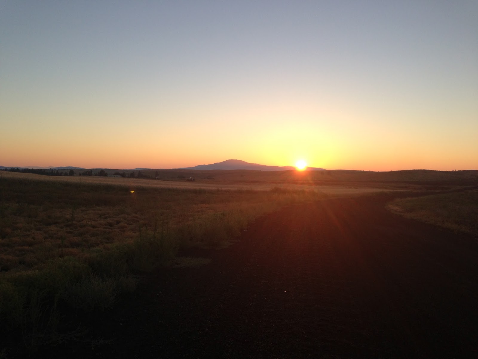
Leaving Avery, I was a bit more relaxed.  I stocked up on fresh water at the little store there, talked to some Forest Service guys who were also heading out for the day.

Outside of Avery the scenery continued to be beautiful.


It was going to be another warm day and I considered taking off my helmet.  But then I thought if I come across a bear, maybe it would help to have a little extra head protection because who knows how long it would take me to find the bear spray. Also, I remembered how easy it is for me to crash just riding along and hit the ground hard, so I opted to keep the lid on.

Below is one of the Milwaukee Road signs somewhere along the way.  At first I couldn't figure why the maps were so high up as to be impossible to read, until I figured out they were up there that high for snowmobilers.

About 7 miles past Avery there is a bridge over the river to the St Joe Ranger District office.  I didn't check it out because I was still in catch-up mode.  Maybe 6 miles more I came to a paved road and the trail ended. (I figured out later it is the St. Joe River Road).  There was a sign for the Milwaukee Road pointing back the way I came but nothing telling me if I should go left or right.  I went right and over a bridge over the river, and then took a left onto a dirt road signed as Potlatch Rd.  It followed the river, so I figured it must be the right way.


Tunnel 37, The Herrick Tunnel:

Unidentified biker hanging around the tunnel:

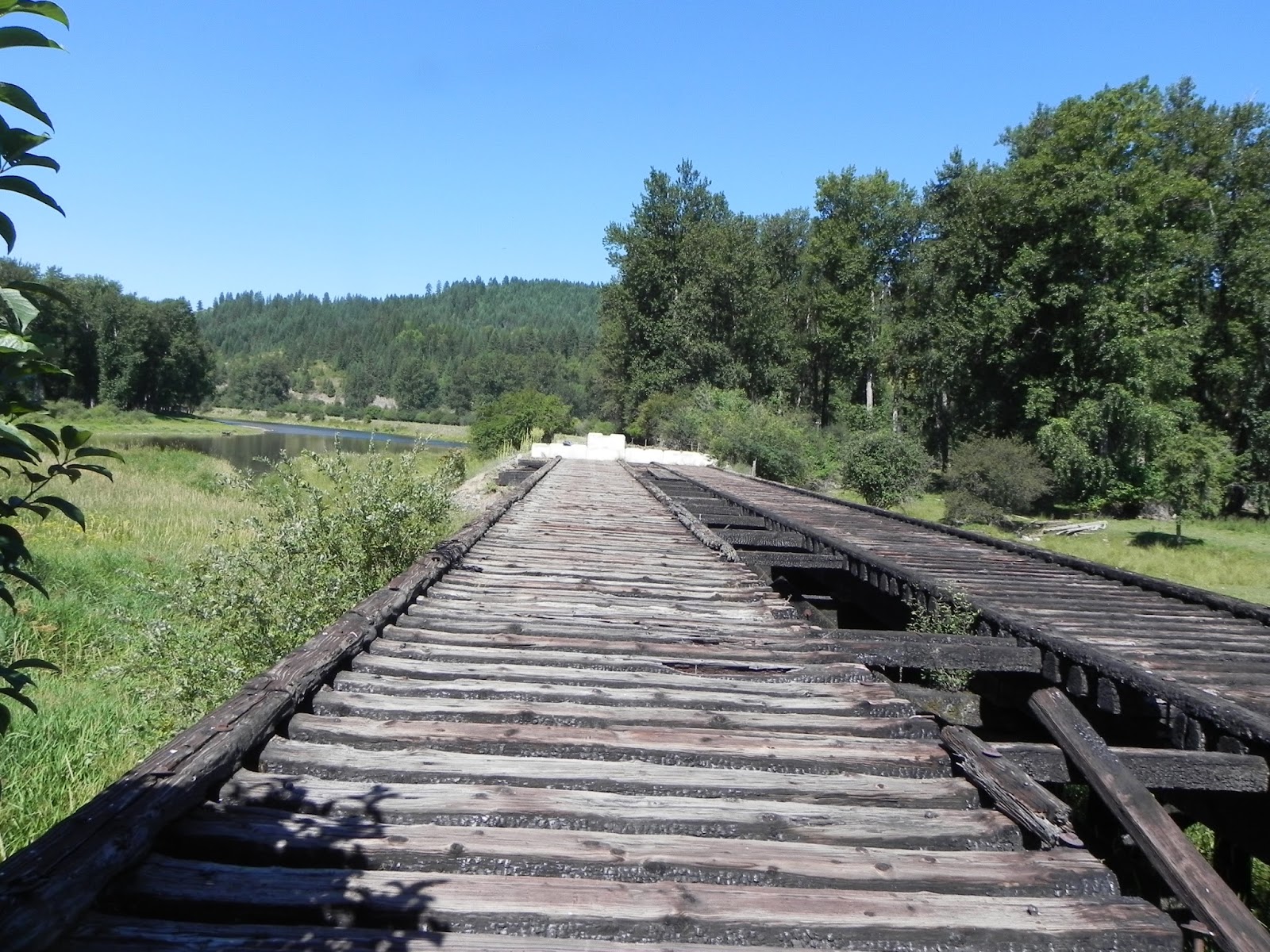
A few miles later I arrived in Calder, and a sign said the Bridge ahead was closed by Order of the Sheriff, or by the County.  Maybe both.  There was a store there that I almost went in to ask if it was passable, but then I thought about it.  The sign didn't say the bridge was out, just that it was closed.  I was a little determined to stay on the Milwaukee Road, so I rode on to check it out.

Sure, there were some planks missing, and a lot of charred wood from a fire, but I walked a few feet out on it. It seemed like it would hold me, and maybe my bike and bags, too.

And it did. The creek below didn't look too deep, so if you're unsure of the bridge you could probably cross the creek instead.

This is looking back after crossing the bridge.  I thought maybe this was a campground at first, but it was probably somebody's piece of land.  Nobody seemed to be around, or didn't care what I was up to.

Just beyond the bridge the trail became a little sketchy, but I made it through without any flats.  In the distance you can barely see another barricade blocking off a smaller bridge.

A few miles further was this interesting old steel bridge:


Maybe a few miles past the bridge there was an intersection that had me confused as to which way to go, but I continued on along the road as it followed the river.

It was maybe 15 more miles of pedaling on dirt and gravel road before I reached St. Maries.  I biked around a bit, looked for the bike shop there but didn't see it.  Parked myself at a grocery store with a Zips in the parking lot.  Then, after turning my phone off and on I finally discovered there was cell phone service there, and I texted Debbie to let her know where I was. It was Sunday afternoon now, and I pondered if I wanted to go further.  I thought it was about 30 miles to Heyburn Park on Highway 5, and back in Kellog the guy at the bike shop told Eric and I that it was a death trap.  So I got me a root beer float and a burger at Zips.  Then Eric called, said Heyburn was only 5 - 7 miles away and he had a camping spot.

Feeling refreshed, I hit the road again.  The road wasn't as bad as the bike guy said it was, and there was a little bit of shoulder with gravel sometimes off to the side to ride on.

Back to Chatcolet Lake:


Eric had a great spot for camping that was on the hill above the parking lot.

Wrapping this up - we left early the next morning and made our way on the Trail of the Coeur d'Alene's to Plummer and then over a pass to Fairfield.

looking back at Plummer

I forget just which roads we took back to Spokane. Stopped in Fairfield, talked to some of the locals. Took a break at the Freeman store and got an ice cream cone.  I was hoping to lose a few pounds on this trip, but I think I managed to consume as many calories as I burned.
looking more like Spokane area
We rolled into Spokane's South Hill around 1:00 or 2:00 maybe.  Eric and I are both thinking we might have to ride this again, with an extra day or two to explore some of the many side trail and roads along the way.

I used to get embarrassed when people would introduce me to others as a strong cyclist. I think of the roadies who are actually in good shape and ride fast, or the other cyclists who ride long distances as the strong bikers.  I tell them I'm just good at working the gears, finding an easy gear and spinning, not working too hard at it. Now, after this ride and the Midnight Century, I don't think I'll be embarrassed if called a strong biker. I know I'm not real strong, but I seem to manage ok.


Tuesday, August 6, 2013

Midnight Century 2013

the Midnight Century was pretty cool, or "neat" in the immortal words of Kevin Costner and Annie Hall.  Didn't really do any training for it except the usual riding to and from work.  I'm always surprised how well that keeps me ready for longer rides.

My wrist Garmin showed a final distance of 93.56 miles versus the official 96.2 miles.  I forgot to turn on the timer at the start and remembered to just before the Opera House, so I'm missing a few miles. I'm going to count the 5 miles to and from home so think managed over 100 miles. Also I missed a turn in the Liberty Lake area, but luckily one of the 3 guys with us knew the area and got us back to the course.  Luckily we didn't get disqualified.  (I was also carrying a second little hand held type Garmin that I had loaded the gps track onto but it was only showing the first 10 miles and the topo map didn't show Liberty Lake area streets.)

Had a fast ride out on the Centennial Trail to the state line with a group of 15 or so before we broke up.  Eric was leading the pack for quite a ways before somebody else took a turn up front.
Rode by myself for some miles, not knowing really where I was, trying to keep the red blinky lights ahead of me in sight.  Had the cue sheet held on my stem with a big paper clip per instructions, it's so dark out there it's easy to miss a turn.

It was a beautiful night.  Quite something to be riding alone in the pitch dark hoping you're on the right road.

Surprised to see the Garmin shows I was stopped for 40-some minutes.  A few times I waited for other riders to show up behind me, stopped to put on a long sleeved shirt at Sands Rd only to discover there is a long climb up Sands and Bruna (a guy who stopped there kept on saying he wasn't looking forward to it) and I wished I didn't put it on; fiddled with my rear blinky which got stuck on steady then wouldn't turn on. Think some dirt and grime got in it.

The rear light not working worried me on Hwy 27, so I waited for a couple guys first. No traffic anyway.

Many times I wished I was riding the Vaya with it's low 34 x 36 gear instead of the Conquest Pro and 36 x 28 low gear. Especially the climb up Spangle. Prefer the tires on the Vaya, also.
A group built up at the top of Bruna, resting and waiting there before we started down.  I got going a little too fast and almost bit it, but stayed upright.

Crescent moon
Ran into Eric and Hank again somewhere before Dunn Rd.  Before Spangle Creek, Eric stopped ahead of me and asked if I'd seen a porcupine back there - he'd ran over one, or its tail.  Didn't notice his foot at first:


Rode in the last part from Spangle mostly with Hank, his brother John, and Eric.  Took it easy on the last 10 miles from the Fish Lake Trailhead to Spokane.  Great breakfast at Central Food, where I decided I didn't think I needed to do the ride again. But you know how that goes.


Friday, August 2, 2013

Bitterrot Loop - Wallace to Avery

This post is a bit wordy...you've been warned.  I won't be hurt if you just look at the few pics.

Let's back up...On The Friends of the Coeur d'Alene Trails website, there is info on the Milwaukee Corridor on the Other Trails page.  The route is listed with directions under Trail #14 Pearson to Marble Creek (map) & Trail #15 Marble Creek to St Maries (map).
The Nor Pac Trail from Mullan to Lookout to the East Portal of the Hiawatha Trail is listed as Trail #9 (map).

This would've been good information to review before the trip but I never got around to looking at it too closely.  I found the website a bit confusing sometimes.  Besides, Duane knew the whole route as he'd taken a group of Boy Scouts on the Loop a few years before.  No problem.  But of course we all ended up going our separate ways.

I did have the Recreational Trails of the Idaho Panhandle put out by the Friends. A good map to have, but with just an outline of the Milwaukee Corridor.  It seemed pretty straight forward.


Ok back in Wallace...

It took awhile to get the bikes switched out, but with Debbie's help I got my gear moved from the Bob trailer to the panniers on the blue Redline and a backpack.  Turns out she's an expert bike packer. Probably left Wallace around 11:30am.  I had called Eric earlier and left a message letting him know I was on my way.  He called later and said good, you can make it to Avery.  That would get me back on track I think with our original loose schedule.

I only took a few pictures from Wallace to Avery - in fact wasn't too interested in pic taking the whole trip - as I was concentrating on getting down the road.  Nothing really to report about the ride from Wallace to the end of the TCd"A at Mullan. I was surprised to find I think I preferred hauling my gear in the panniers instead of the trailer.  I have 35mm Paselas on the Redline and they rolled a bit smoother than the Clement X'Plor MSO's on my Vaya.  I wasn't sure how they would handle on the rockier trails past Mullan but I would soon find out.

Made it to Lookout via the Nor Pac Trail:


At Lookout ski area I asked how to get to the Hiawatha Trail by bike and the guy at the counter said "you don't have a vehicle or somebody to take you there?" um, no. He said to take the trail to the right of the brown dumpster behind the building. After getting a sandwich and pop, refilling with water, I headed out.  Found a paved road and a dirt trail with a sign marking it as the Nor Pac trail. I didn't realize at this time that the Nor Pac trail headed to the Hiawatha Trail.  After going on it a bit I wasn't sure if I was headed in the right direction so I went back to the ski area.  A woman behind the counter said well there's a big sign and map there.  There was, but it didn't say in big letters "This way to the Hiawatha Trail" which is what people like me need.  But she pulled out a hand drawn map for me (the Wallace RV Park had a similar one showing the way to Lookout) and highlighted the route for me.  I was expecting a short trip to the Hiawatha and it turns out it's a nice 5 mile meandering route down the mountain (except last two miles are uphill) which took maybe an hour or so. Seems like I was on it a couple hours.


I made it to the Hiawatha trail in the late afternoon and was one of the last people riding down for the day.  One of the Rangers was performing sweep duty and advising people if they wanted to catch the bus back up they ought to hurry along.  She figured by the looks of me and my gear I was riding through.

At the bottom of the Hiawatha at the Pearson Trailhead it's a little tricky to find the Milwaukee Corridor. You take a right out of the Parking lot, and go back in the direction of he Hiawatha, then take a left over a bridge.  There's tall sign (for snowmobilers) with the Milwaukee Corridor logo on it.  It read "well groomed multi-use trail".  Once across the bridge you go left...onto one of the bumpiest, rockiest dirt roads Pasela tires have probably ever seen.  Maybe it's just well groomed in the winter.  It was so rough I wished I had the fat bike.  I seriously wondered if I was on the right trail.  There was no cell service, but my phone's compass assured me I was going south/south easterly so I kept going. And going. Sorry no pics, I was concentrating on moving along.  It was only about 8 miles I think to Avery but it took a long time.  I was riding around in the back woods of Idaho in knickers with a pink speedometer on my bike, but eventually I stopped and asked  a couple of fly fishermen if I was near Avery.  They said "sure you're almost there.  In about a half mile there's a fork in the road, and you take the right fork. It's steep and you'll want to walk your bike, but then Avery is real close." Turns out Avery by bike is not so close.

I get to the top of the hill and it connects to another dirt road.  I can't remember if they said to turn right or go left over the bridge over the river.  I go right and pedal away.  Still no cell service and I realized why it would've been a good idea to bring a Garmin.  Come to a one lane tunnel, and there's no markings relating to the Milwaukee on it.  The guy didn't say anything about a tunnel. At this point the light is starting to fade, but I work up my nerve, turn on my headlight and head in. Come out on the other side fine.  Pedal some more.  I see a guy in a truck going the other way and he's eating an ice cream cone so I figure we must be near a town.  But after a bit I think I must be going the wrong way and I turn around.  Back through the tunnel and across the bridge.  Eventually I wave down a couple on an ATV (lots of ATV traffic) and they inform me Avery is the other way and there's a couple more tunnels to pass through. Oy! Both times that I second guessed myself and turned around, I was going the right way.

It was getting near 7:30pm and I kept pedaling fast, wanting to get into Avery before dark and to reach a phone to call Debbie and let her know I made it.  I could just see a Dateline Special "The Missing Biker".  They'd talk to people who saw me going one way, and others who saw me heading another way.  Just what was he doing out there?

I finally roll into Avery around 8pm.  My contacts are foggy from all the dust and I can't see very well but there looks like a campground on the left. I find a pay phone (yes I used a pay phone for the first time in like 20 years, I didn't know they still worked) to let Debbie know I was camping in Avery.  I ride around but don't find a campground, the spot I thought was a campground is somebody's residence or vacation spot. There was actually some sort of hotel next to it with some young women sitting around, having a good time.  The only campground they could think of was the St Joe campground a few miles back across the River.  I asked about lodging and they said well this is a hotel. I looked around, and couldn't really see very well so I passed on it.  Besides staying at a hotel wouldn't be in the spirit of the trip.  Thought I'll head down the road and find spot.  But a woman at the place I had thought was an RV Park saw me wandering around and told me I could stay in the field next to them as it was Forest Service land.  They'd seen another biker come through but he was hours ahead of me.  I was tired and ready to stop so I set up my tent.

My campsite the next morning:

I headed out and lo and behold just over the bridge there's a nice RV Park.  If I'd gone about 20 yards further the night before I would have seen it.  But having camped in a field,  I'm starting to feel like a real bike camper.