Sunday, August 24, 2014

Martin Rd Bikexpedition

Now that it's cooled down out here, I did some bikexploring with the Fargo on Saturday from the Columbia Plateau Martin Rd Trailhead. After studying my DeLorme Atlas, the plan was to head a few hundred yards north to Cree Rd and take it down to Dewey Rd, to Cordell Rd, then to Mullinix. Then I would follow Belsby down to Hole-in-the Ground to Rock Creek, Pine Creek and the John Wayne Pioneer Trail like I did last year (Martin Rd Trailhead to John Wayne [gps]). I wanted to make a loop, trying to add a few more miles than last year, but ended up with an out and back with slight variation on the way back.

the patent-pending wileydogmapcap. the trailhead and
Cree Rd are in the upper left-hand
Well that was the plan.  There's a funny thing about the atlas, gps and actual on the ground road signs - they don't always agree. And it's awful hard to read tiny gps map screens in the bright sunlight with old eyes. I missed the first intersection on the Lincoln-Whitman County line, neither road sign had Cree on it and I went east instead of west. Link to the actual gps of the ride. The map and gps call the road I took Stoner Rd, but I it was signed in a couple spots as Swift Rd. I'll have to go back and check at this intersection as not sure if I have it straight now.

This worked out pretty good as Stoner Rd becomes a rough dirt and rock road akin to the gated off Dunn Rd/Summer Road of the Midnight Century. A little too rough for most vehicles in spots, but perfect for 2.2" mountain bike tires.

Back to the start:

Cree Rd
There must have been a hole in the barbed wire fence as I came across a calf on the road that took a little run at me, and then a group of 10 or so cattle loose on the road. Thought I was going to have to turn around. They panicked and tried to jump back over the fence, and then ran up the road ahead of me.
felt like a bicycle cowboy 
they finally found an opening near where the Columbia Plateau Trail
crosses Cree
the intersection where I turned right instead of left. the gps names
the road to the left as Elliot which becomes Cree again. i forget what
the sign said now.
Stoner/Swift Rd. 

The road is just a stone's throw away from the Columbia Plateau Trail in spots, and I remember we stopped for a rest by this road on our trip last May. I was tempted to stay on Stoner to see where it goes, but turned left on Dewey instead. I saw afterward Stoner/Swift will take you into Lamont.
back on gravel on Dewey
what's that up ahead? a dirt summer road?
 Munson Rd. It wasn't in the plan, and I wasn't sure where it went, but I had to take it.

It finally popped out on Rock Creek Rd and after I got my bearings, determined I was way further east than I wanted to be. Rode northwest on the paved Rock Creek Rd before backtracking on Munson Rd back to Dewey. Rock Creek Rd wasn't the type of ride I was looking for. Also, may not have had my helmet and felt a bit vulnerable. Hardly any traffic, though.

Back on Dewey, passed Cree Road after awhile and so was back on plan, looking for Cordell.
think this is off Cordell 
probably Cordell again. really need to find some way to sync the
camera with the gps.
I had been out for over a couple hours and didn't feel like making this an all day trip, even though I wanted to ride down Belsby, so instead took Mullinix to Martin Rd (Williams Lake Rd) back to the trailhead. Martin is a narrow paved road without a shoulder - think a more roundabout way back down Spuller to Dewey to Cree looks promising.

Think will head back out in a couple weeks, getting an earlier start and follow the same way down Cree to Stoner to Dewey, skip Munson and head down Belsby.  I like exploring these gravel and dirt roads in this area - the only problem it's an almost hour long drive to the trail head.


Friday, August 15, 2014

Midnight Century or A Whole Lotta Hills

whoa it's been almost two weeks since the Midnight Century!  Happened a week ago last Saturday at 11:59pm or so and continued throughout the night and early morning. I thought I was going to be lucky if I made it in by noon. Almost brought a bivy sack or tent along in case I broke down. Thought somewhere along the line if I dnf'd, no one would really know. But I banished those thoughts and kept pedaling on, a long and dusty ride.

First, a video collage of the first 20 miles or so heading out of town is on youtube here. The unofficial gps file I poached from the MC website is here

My rides the month before were generally only commuting, and not going for any long rides. Too hot. No hill climbing up Houston Rd to build some muscle.  And if there's one thing about the MC, well besides it being mostly in the dark, is that there is tons of climbing. I thought it was possible I could do better than last year's 8h15m, but figured I'd be lucky to break 10 hours.

After the flat fast ride to the state line, the course starts climbing and climbing and climbing the hills above Liberty Lake.  I fell behind Eric E and the group we were riding up the hills with, but I figured I would catch them on the downhill. But my legs felt like mush, I fell too far behind and lost track of them - until some hours later when I think I came across part of the group after they took a wrong turn.

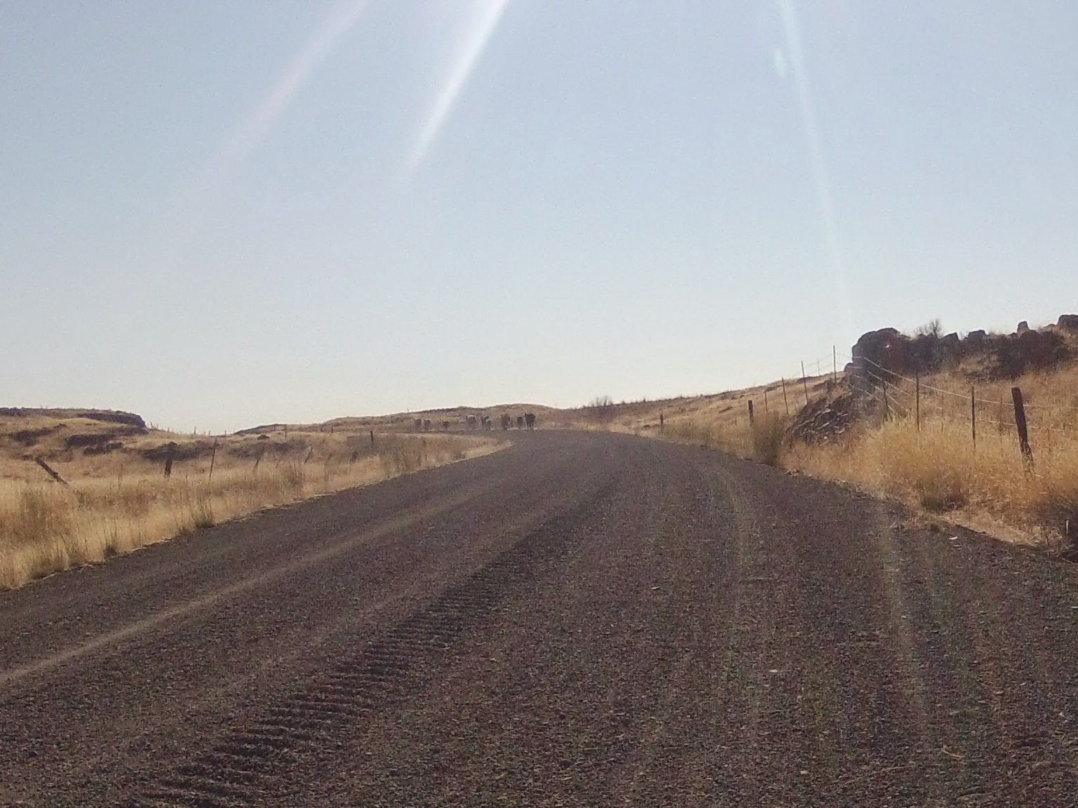
Here's a typical view, maybe out on Belmont Rd:

It wasn't all pitch black, as we rode by various farms, homesteads, small communities.


Some blathering about gear:

Bike/Tire Talk: I was riding me Salsa Fargo, and appreciating the tubeless setup.  Passed quite a few guys on skinny tires fixing flats along the way.  Or maybe it was just the same one or two guys fixing flats I kept passing.

The Race King 2.2" tires roll surprisingly well on pavement, but there were lots of miles on the paved roads where I thought the tires might be overkill.  But then there many sections I was glad I had them. Like the gated off summer road (a road in name only), the downhill dirt Bruna Rd, and all those washboard gravel roads in the last half. Took the sting out of the bumps. Had 30+psi in them and maybe could've gone lower.

Garmin talk:  This year I had the course loaded on a Garmin Edge Touring model, and I could just follow the purple line. The screen would tell me when to turn.  This was working great except for a few spots like around Liberty Lake when the screen went dark. I thought maybe I lost satellite reception but I couldn't read a message at the bottom, telling me we were off course, so I think I missed the same turn before LL we missed last year.  Darn fuzzy contacts. We soon were back on the course and riding with a larger group again. Took me awhile to get the Garmin back on the course, but once I did it was back to following the purple line.  Helped a few riders find the turns along the way,

Later on I got the Garmin off course again by tapping on the wrong spot on the screen, and it decided I wanted to go where I tapped. Then it would tell me to turn around, make a u-turn but I could see the purple line going the other way. Luckily one time when it told me to go the wrong way, there was another guy who knew the right way to go.  At least now I know more about working the Garmin.

Shoe talk: my trusty, sturdy heavy duty 5-10 Freeriders. After 80 some miles these were feeling heavy - next year if I do the ride (well of course I will if I'm in the Spokane area) will wear something lighter like the Chrome shoes. I was having trouble with the hills and once or twice even thought maybe I should've gone clipless - gasp.  Around 3am I got a second wind and started just mashing down on the pedals on the uphills - that seemed to help. No spinning in tiny circles for me.

More cell phone pictures time:
Sunrise some miles before Spangle
a welcome coffee/cookie stop
they really don't want people getting past the
end/beginning of the new pavement on the Fish Lake Trail
Wildlife: 3 porcupines (close encounters only), lots of deer. other critters heard but not seen.

Downhill talk: I'm always surprised my heavy steel bikes coast downhill about as fast as most light, skinny tired bikes.  Noticed this first at Spokefest some years ago riding my Marin Muirwoods with its smooth 42mm tires and it continues with the Vaya and Fargo.  It helps on gravel roads to have the fatter tires give me a little more confidence and not hit the brakes as much.  I like going fast downhill, but after awhile thought maybe it's not smart to I push it too fast, especially when by myself out in the middle of nowhere. Thinking I was a downhill racer in another life.

food: brought trail mix and some Bobo Oat bars that looked similar to my favorite no-bake cookies. Except they weren't: they were dry and not much flavor. Didn't feel like eating much, think next time will bring some cookies, apples and a sandwich. Don't like the sport bars and gel-packs.

picture chronicling: think will fix a regular camera to the handlebars or rack next time, or carry a good small camera. Attached the gopro to my front rack with a ski pole attachment, but I had to build up the rack tubing with duct tape because it was a little too narrow. Made for a wobbly mount. The gopro battery died quickly and I need to get a new battery.  Not that there's a lot to take pictures of in the dark, but it'd help with a proper ride chronicle.

For all the tough uphills in the first half of the ride, the last 20-30 miles are the toughest for me, even though they're the flattest.  Especially the last few miles on the Fish Lake Trail - just wanted to get to Spokane. Stopped a bit extra more in the last third to re-group, but I wasn't in any hurry. Finished up at Central Food and chatted a bit.  Almost fell asleep trying to talk myself into riding home but hoping for a lift. No ride was available, so I took an easy meander home.

The MC is a great ride and I'm glad I finished.  There's something about riding in the middle of the night on the back roads, sometimes alone, sometimes with a group of strangers and friends.


Thursday, July 31, 2014

Bell Boy!

I picked up the Incredibell Omnibell:
- it has a stretchy band that fits 22mm-31.8mm handlebar widths and a moveable dinger. I was able to mount it out of the way on the stem and rotate the dinger to an easy to reach position. Incredibell also makes a couple headset mounted bells, but the shop didn't have any.

After a bike ride one Saturday morning I met my wife and her running group at a coffee spot. Before I could make a polite exit to ride home, the talk turned to bikers passing runners without announcing their presence on the Centennial and Fish Lake Trails. It's a bit of a sore point with them. A couple are bikers also so it wasn't all anti-bike. I mentioned how many walkers/runners take up the whole trail, and have earbuds on. Or move to the left when you say "left" or ring the bell. I'm not one to say something every time I pass runners, usually only when they need to move over so I have room to pass.

They see it differently.  A biker should say "on your left" or ring the bell every time they pass runners/walkers.  One of their friends was telling every biker that passed silently by, "you're supposed to say on your left".  To which she got flipped off by one biker. But do you really need to say something every time you're passing somebody? I guess that's the rule, but it gets old. They know they're on a multi-use path with bikers and should be expecting them to pass by.  That's how I see it when I'm walking on one of the trails. But Debbie said she's been startled by bikes passing by when she didn't realize any were near.

So I broke down and thought I'd give the bell another try. Haven't had much chance to use it yet - only been on the Centennial Trail a couple times this week, and I try to avoid it during busy times.  So far  I've forgotten to ring it when I've had the opportunity to use it as a warning or a "hello" to fellow bikers. Might have to go practice it by riding around Riverfront Park.


Thursday, July 24, 2014

Rock Creek Rec. Area/Escure Ranch


I cheated and drove out to the Rock Creek Recreation Area last week - postponed a bike overnighter until September.  Maybe August depending on schedule and heat.  On the way down on Jordan Knott Rd passed by the Lamont Grain Growers silo near Revere where Pat, Eric and I re-filled our water bottles a couple years ago on the John Wayne Pioneer Trail. A good spot to remember there's a water hose there.

Here's the Garmin for my ride around Escure Ranch/Rock Creek Area and a separate one for the 3-mile trail from the parking lot to Towell Falls. I explored a couple roads/trails while out there.

Here's plenty of pics of the area: dry, dusty, cheatgrass, a little swampy, basalt - almost everything Eastern Washington has to offer. And hazy sky from the Central Washington fires.

just two other vehicles in the parking area - talked
to a guy who was camping at Williams Lake with
family and was getting away to try the fly fishing here
a little history
the road from parking area to the Ranch and bridge over
Rock Creek

map says this is George Knott Rd leading out from the
 ranch

a little single track diversion which ed to the below
panorama
returned to the road, then veered off onto another road/trail
this could be the north end of Wall Lake.  you might be
able to see a deer and fawn in the left central portion.
they paid no attention to me
just as I arrived at the JWPT, this feller sauntered onto it
from McCall Rd. He didn't notice me, appeared to not
be doing very well
he stopped and looked back at me but I didn't register on
his radar until I said hey buddy and he ran back up
McCall. felt bad for making him run. That is the Columbia
Plateau Trail overpass in the background.
back at the ranch, trying to be artsy with the camera
phone


this is probably for horses since it's by the corral. also
by the parking/picnic table area.  I also found a
spigot at the ranch but water wasn't on.
3 miles to the Towell Falls
road veers off to the left then climbs up a bit before
reaching the falls

When I got back to the parking lot the fisherman had left so I didn't find out if he had any luck. Haven't fished in years, but interested to find out if the fishing's any good here.  Would make a good addition to the bike camping food.

Will have to return to explore some of the other dry dusty trails.

Monday, July 21, 2014

biggest shiniest rack I could find


There're a few reasons why I've been wanting a different front rack.  The Racktime Topit is ok but the platform is narrow for my needs. The Orleib panniers were rubbing on the Salsa rack, so I switched to the backpack again. The backpack, though convenient, was bothering my back. And neither the backpack or panniers carry some bulky items very well.

So I went for broke and got the Velo Orange Porteur Rack. Or if you don't like the French word, call it a Freedom Rack. Or pizza rack, since at 14" x 11" it's a good size to carry pizza home (without the fence).

I look at the bike and go yikes that's huge and so shiny! Looks a little out of place, but maybe I just need to get used to it.  Maybe should've gone with the Soma rack which has a basic black option. Think also maybe should've been patient and ordered a 3-rail Cetma rack - something narrower than the Porteur racks, but wider than most other front racks. Second guessing.

It's a type of rack that works best with a low-trail bike, so they say, instead of the Vaya. It reminds me of that insurance commercial - "that's not how it works".

But whaddya know - it works for me.  For now, I'm bungee cording my backpack to the rack, and when I have the load balanced it handles pretty good.  Feels great to get the backpack off my back, especially in this heat.  I like the way the rear of the bike handles without weight back there - the bike is a little more zippy.  The front from handles a little differently - mostly I notice it when biking uphill it feels like I'm pushing a load which I guess is what I'm doing.

I'll see how this slightly expensive experiment goes. It might work out and I won't just have an item to add to the craigslist/bike swap list.


Tuesday, July 15, 2014

Tubeless Fargo

On the Salsa forum over at mtbr.com I read one post that said the Continental Race Kings that came standard on the 2013 Fargo don't work well set-up tubeless, and another post that said pshaw, no problems.


So I gambled and bought the Stan's valve stems and sealant. Since I don't have a presta fitting thingamajig for my compressor, I went back to the Bike Hub downtown and had them set the bead for me. I was duly warned of a good chance of failure using the tubeless rims with non-tubeless tires, and they'd had disappointed customers.  I assured them I wasn't one of those guys.

The tires seemed to set up good in the shop and were holding air, with a few spots of sealant leaking out.  I took them home and had to air them back up a few times that day.  Left them over night and front tire was flat in the morning, but the rear was holding steady.  Pumped about a 1/2 oz. of sealant in the front and it held throughout the day.

This was all in prep for a 2-3 night trip this week down Belsby/Hole-in-theGround Road to the John Wayne trail then to Escure Ranch, but the heat wave got to me.  Maybe later this week.

Took the bike out to Riverside State Park on Monday for a test of the tubeless setup and to see if I could trust it to hold over a multi-day trip out in the boondocks.  Rode over all the worst Trail 25 has to offer - those rocky sections by the river, those rocky sections up in the hills, canyons, everywhere.  Waited to hear the dreaded burping, but nothing.  I think I felt a smoother ride. Worked fantastic and only lost a little bit of air - probably from checking the pressure.

Now I'm looking at those fatbike tires.

Wednesday, July 9, 2014

Hand Signals/Re-thinking the rear brake

oh boy, two-posts-in-one
When I started bike commuting I read up on the bike traffic laws and discovered the alternate right turn signal - extend your right arm outwards (RCW 46.61.758). Ditched the the awkward left arm bent at the elbow pronto.
handy card from Washington Bikes. didn't notice the
requirement for brakes that skid the wheel until now.
Some bikers who use the left arm for both signals route the front brake to the right handlebar and the rear brake to the left, so they'll always have the stronger brake available on the right when signaling.  Using the right arm signal means you can't use this setup, but I don't see that as a problem as I never really need to brake hard while signalling.

RCW 46.61.758 says "The hand signals required by this section shall be given before initiation of a turn".  So I usually brake a little if I have to, then throw out the arm, and return my hand to the handlebar for the turn.  Can brake with the opposite hand if needed to slow down during the signal.

Which leads me to re-thinking the rear brake. Since discovering the front brake is the more powerful one, I've been dutifully favoring it. In case of an emergency stop, I wanted it to be second nature to use the front brake.  Found out quickly on the rocky trails out at Riverside it's a different story mountain biking, but around town I apply more pressure with the left hand.

But a couple times I've crashed during a low-speed turn because I locked the front wheel.  Both of these happened on the Marin Muirwoods with it's cheaper disc brakes, so that could be part of the problem.  It got me worried every time I turned into a driveway or attempted a sharp turn.  I finally started using the rear brake more in these situations and re-gained my confidence.  I also re-learned the obvious - try braking before the turn, not during.

Since then, I've been using the rear brake more when I just need to feather back on the speed a little, as in approaching turns.  Sometimes it's just the rear brake, sometimes both. I've gotten better at  reflexively using either or both brakes when I need them.